


Best Paved Roads in California Map Bundle - Northern & Southern California G1, Pacific Coast Highway
Couldn't load pickup availability
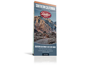
**Best Paved Roads in California – Bundle**
California is one of the great motorcycling states on earth. From the sunlit bluffs of the south to the fog-draped redwoods of the north, the roads here are as varied as the landscape itself — and this bundle puts the best of them in your hands.
The **Best Paved Roads in California Bundle** combines three of Butler Maps' most essential California titles into one complete package: the **Northern California G1-Series**, the **Southern California G1-Series**, and the **Pacific Coast Highway Experience Series**. Together, they cover the state from the Oregon border to the Mexican border, with the coast stitched together by one of the most iconic roads on the continent.
**What's Included**
*Northern California G1-Series* — From the Oregon border south to Watsonville, this map covers foggy coastlines, giant trees, granite spires, and the roads that cross them all. The Butler team rode over 30,000 miles to document and rate every highlighted route — from Hwy 299 and the Avenue of the Giants to the remote stretches of the Lost Coast and Death Valley. Paved Mountain Trails, dual-sport options, and detailed inset boxes round out one of our most comprehensive maps.
*Southern California G1-Series* — From the Mexico border north to Monterey and Bishop, this completely redesigned map covers over 600 miles of new and updated G-rated routes with updated road data throughout. Forty-nine inset maps highlight top-rated rides — from iconic stretches like Angeles Crest and King's Canyon to hidden gems like Kaiser Pass, Italian Bar Road, and Beasore Roads. PMTs, dual-sport roads, and Butler's patented ratings are all here.
*Pacific Coast Highway Experience Series* — Where the other two maps cover the breadth of the state, this one goes deep on a single corridor. Designed for an unhurried south-to-north journey along California State Route 1, it highlights the most meaningful stretches of the coast — scenic segments, short walks, historic lodges, coastal towns, and quiet pull-offs — across more than 600 miles of road where the mountains fall into the sea.
**Why Bundle**
The G1-Series maps show you everything. The PCH Experience Series slows you down and focuses you. Used together, they give you a complete picture of California's paved road landscape — from the remote mountain roads of the interior to the wind-swept edge of the continent. Whether you're planning a weekend loop, a two-week tour, or a full coast-to-coast crossing, this bundle has you covered.
All three maps are printed on durable, waterproof, tear-resistant synthetic paper — built for the road, not the shelf. Butler's patented road ratings make it easy to find the best pavement at a glance, and hundreds of points of interest, campgrounds, fuel stops, and elevation details keep you oriented wherever the road leads.
*Northern and Southern California G1-Series maps are also available for digital use in the Avenza app and the REVER app (premium subscription required).*